Community Preparedness
When emergencies happen, it’s often our neighbours, local groups and marae who are first on the scene to help. That’s why community preparedness is such a vital part of emergency management in the Tararua District.
Tararua District Council works with communities across the district to develop Community Response Plans. These are locally driven plans that outline:
- The risks specific to your area (like flooding, isolation, or power outages)
- Key people and local resources that could help in an emergency
- Safe meeting places and local support networks
- How to stay connected with Civil Defence during a response
These plans empower communities to act quickly and confidently while help is on the way. They’re living documents – updated regularly with input from the community.
Tararua District Council supports local Civil Defence community groups by:
- Helping set up or refresh plans
- Providing training and resources
- Sharing hazard and emergency information
- Staying connected during activations and recovery
Civil Defence Community Groups have been established in multiple urban and rural areas across Tararua, including Dannevirke, Woodville, Pahiatua, Eketāhuna, Norsewood, Pongaroa, Ākitio, Herbertville, Alfredton, Weber, Makuri, Te Uri, Ormondville and Kumeroa.
Each hub is equipped with welfare supplies and essential gear. Five of these groups were created in response to Cyclone Gabrielle, with strong support from our recovery team, who have worked hard to get them up and running.
In a disaster, your neighbours are your first line of support. A resilient community is one where people:
- Check in on each other
- Share resources and information
- Know who might need extra help
- Work together during and after emergencies
We encourage residents to build relationships with their neighbours and local groups now — it could make a big difference later.
Tararua Community Welfare Hubs
Community Welfare Hubs are local places within the Tararua District that are equipped and ready to support residents during emergencies. These hubs form part of our wider community resilience network and are coordinated with local Civil Defence groups to help provide essential support, connection, and coordination when an event impacts our district.
These welfare hubs are not just places with equipment — they are community meeting points where neighbours can gather, share information, and organise mutual support before, during and after an emergency. You can connect with your local Civil Defence group to find out how your community’s hub operates and how you can get involved in preparedness and response planning.
These hubs are only activated and set up at the time of an emergency. They are not staffed or open day-to-day but will be established when communities need them most.
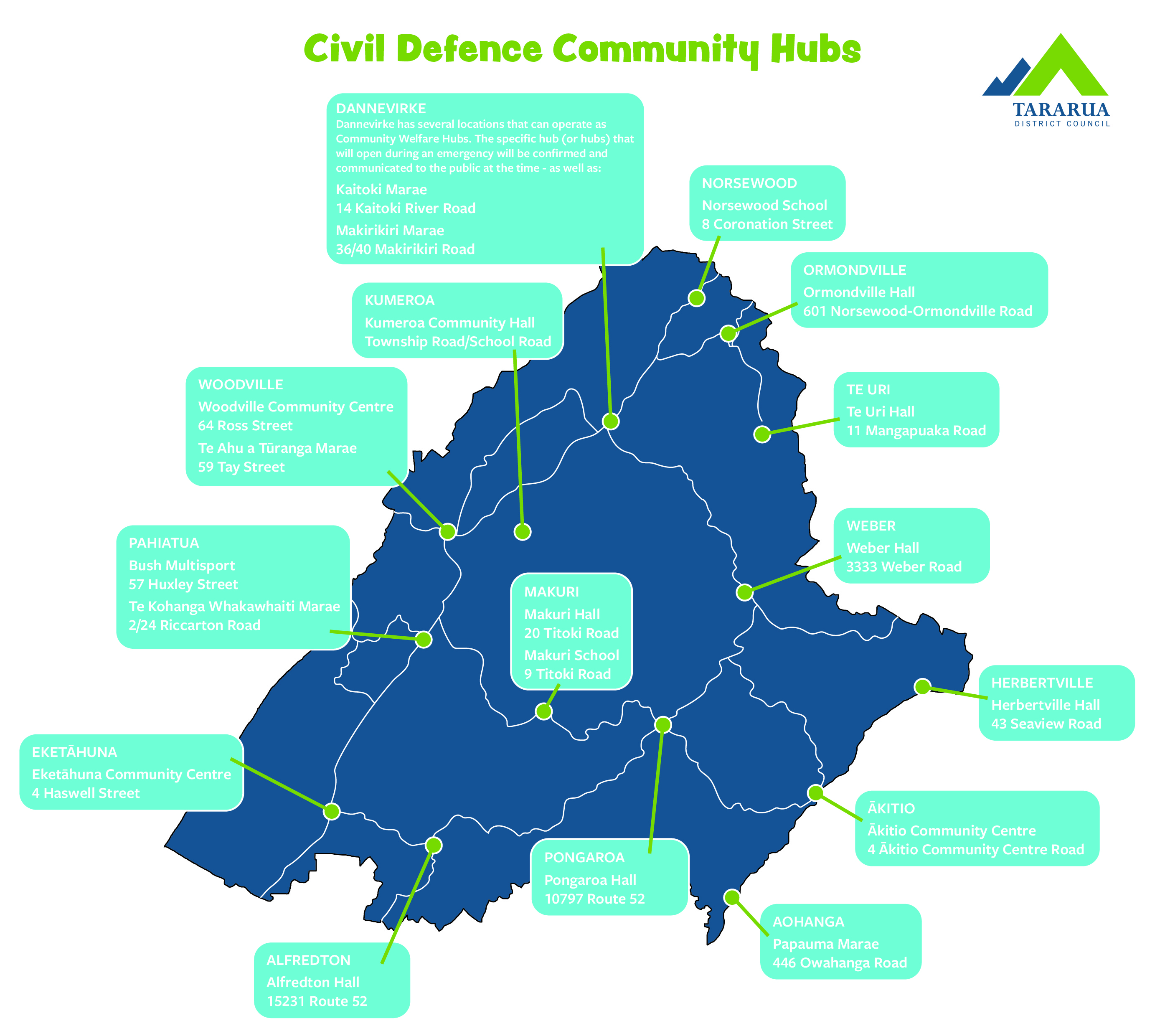
Bush MultiSport - Google Maps
57 Huxley Street, Pahiatua
Te Kohanga Whakawhaiti Marae Google Maps
2/24 Riccarton Road, Pahiauta
Woodville Community Centre - Google Maps
64 Ross Street, Woodville
Te Ahu a Tūranga Marae - Google Maps
59 Tay Street, Woodville
Eketāhuna Community Centre - Google Maps
4 Haswell Street, Eketāhuna
Dannevirke has several locations that can operate as Community Welfare Hubs. The specific hub (or hubs) that will open during an emergency will be confirmed and communicated to the public at the time.
Kaitoki Marae - Google Maps
14 Kaitoki River Road, Dannevirke
Makirikiri Marae - Google Maps
36/40 Makirikiri Road, Dannevirke
Norsewood School - Google Maps
8 Coronation Street, Norsewood
Ormondville Hall - Google Maps
601 Norsewood-Ormondville Road, Ormondville
Te Uri Hall - Google Maps
11 Mangapuaka Road, Te Uri
Weber Hall - Google Maps
3333 Weber Road, Weber
Pongaroa Hall - Google Maps
10797 Route 52, Pongaroa
Papauma Marae - Google Maps
446 Owahanga Road, Pongaroa
Herbertville Hall - Google Maps
43 Seaview Road, Herbertville
Ākitio Community Centre - Google Maps
4 Ākitio Community Centre Road, Ākitio
Papauma Marae - Google Maps
446 Owahanga Road, Pongaroa
Alfredton Hall - Google Maps
15231 Route 52, Alfredton
Kumeroa Community Hall - Google Maps
Township Road/School Road, Kumeroa