Severe Weather Event Updates
Last updated at 11:30am on 22 April
SEVERE WEATHER UPDATE #3 – 22 April, 11:30am
The weather has improved greatly but there are still issues on our roads presenting themselves with further slips overnight.
There are currently 9 roads closed due to slips and treefall and some roads down to single lane traffic or 4 x 4 resident access only.
Both Coast Road and River Road remain closed, with further slips occurring overnight.
Route 52 is open one lane and caution is required due to multiple slips and trees down.
Ākitio remains cut off and closed to all traffic but have power and telecommunications. Ākitio residents are reminded that, in the event of an emergency to dial 111.
Our teams are gathering information on the extent of damage and clearing slips. The road network is still very vulnerable due to ground saturation and continuing rain.
Although the weather has improved, road users are reminded that slips and tree fall can occur for some time after and we advise the following if you are travelling:
- Only travel if essential
- check out current road status at www.tararuadc.govt.nz/services/roading/current-road-status to see if your route is open
- drive to the conditions
- follow any instructions from our roading teams
- report any roading issue by calling 06 374 4080, 06 376 0110, emailing info@tararuadc.govt.nz or using the Antenno reporting app
We would like to thank everyone for their vigilance, following instructions, reporting issues, looking out for their neighbours and their wonderful community spirit.
SEVERE WEATHER UPDATE #2 – 21 April, 5:00pm
Tararua District continues to experience severe weather impacts following heavy rain and thunderstorms overnight and throughout today. The Emergency Operations Centre (EOC) will continue monitoring conditions overnight, with roading, water and welfare teams on standby.
This is our last update for today (21 April). Below you’ll find more information about incoming weather, rivers and flooding, community impacts, roading and access and the council response.
Weather Status
- Heavy rain is expected across the Tararua District until midnight Tuesday.
- A further 70–90mm of rain possible in ranges and coastal hills
- Streams and rivers may rise rapidly
- Slips and difficult driving conditions remain possible
Rivers and flooding
- Rivers and streams remain elevated and are being closely monitored.
- The Wainui River at Herbertville is very high and nearing levels where self‑evacuation may be required at the campground. We are in regular contact with our Herbertville community contacts.
- Surface flooding has occurred in some areas, with conditions improving in Pahiatua but still possible elsewhere if rain continues.
- People are urged to stay clear of flooded rivers and waterways and not to drive through floodwaters.
Community impacts
- Ākitio has received significant rainfall (206mm in the last 24 hours), is currently isolated as Coast Road and River Road are both closed from slips and flooding. Some property damage has been reported, and a small number of residents have chosen to self‑evacuate as a precaution. Crews have been working to restore access, but this will not be possible today. An update will be provided on this tomorrow morning (Wednesday 22 April).
- Herbertville has experienced heavy rain (167mm in the last 24 hours) and power and cellphone outages. Power and cell servive now restored. River levels continuing to rise and being closely monitored, and the campground is prepared to self‑evacuate if the Wainui River reaches critical levels.
Roading and access
A total of 8 roads across the district are closed due to slips, flooding and fallen trees. Another 4 roads are reduced to single lane.
Coast Road is closed and will not re-open overnight. River Road is closed in two places, one to Ākitio and the second to Pongaroa. Active slips and surface flooding are making these roads unsafe. There are alternative routes to Pongaroa, but not to Ākitio. Pahiatua-Pongaroa Road is open.
Please continue to avoid unnecessary travel and follow any detours in place, and refer to our Road Status page for the latest updates: https://www.tararuadc.govt.nz/roadstatus
Council response
- EOC will be monitoring conditions overnight.
- Roading, water and welfare teams on standby.
- Ongoing contact with community representatives, marae and campgrounds .
- Regular public updates continuing throughout the day.
Our message to the community
Please stay informed through official Council channels, avoid unnecessary travel especially near flooded or unstable roads, check on neighbours where it is safe to do so, and be prepared to act quickly if conditions change or emergency advice is issued.
Message us if you need us and if you need to report an issue, please provide as much detail as possible (including photos if you’re using the Antenno app).
#civildefence#emergencymanagement#severeweather#tararuadistrict
Roading update - including access to Ākitio
21 April, 1:30pm
Tararua Alliance roading crews have been inspecting the district since early this morning, with the support of subcontractors. We have received multiple reports of slips, flooding and trees down.
Ākitio is cut off as the two key routes (River Rd and Coast Rd) are closed due to slips, fallen trees and surface flooding. Contractors have been working at both sites. We are doing our best but cannot guarantee that there will be access in/out of Ākitio today as slips continue to come down.
We currently have 9 roads closed across the district due to the weather, and multiple roads down to single lane.
⚠️ If you do need to travel, please check conditions before you head out:
TDC Road Status: https://www.tararuadc.govt.nz/roadstatus
NZTA State Highway Status: https://www.journeys.nzta.govt.nz/highway-conditions
For parents and caregivers, check your school’s social media page, website, or app for the latest updates before heading out.
📻 Radio can be a lifeline
If networks go down, radio is still one of the most reliable ways to get information.
In the Tararua District, tune in to:
📻 Radio Dannevirke – 107FM
📻 Radio Eketāhuna – 106.5FM and 88.3FM
📻 Radio Woodville – 99.6FM (Woodville) and 88.3FM (Pahiatua)
📻 Central FM – 99.4FM and 105.2–106FM
📻 More FM – 92.2FM
📻 Radio New Zealand – 101FM (National Civil Defence broadcaster)
If you can, keep a battery-powered radio handy and save a copy of these stations somewhere you can access it if there’s no internet.
For more tips on getting prepared, head to: www.getready.co.nz
SEVERE WEATHER UPDATE #1 – 21 April, 10:30am
A big thank you to everyone across our district for taking the recent weather warnings seriously and getting prepared. We’ve seen people checking drains, making plans, and looking out for each other, and that makes a real difference.
Overnight weather brought periods of heavy rain to parts of the district. Here’s the latest update on conditions this morning. More heavy rain and stronger winds are forecast, so we’re keeping a close eye on conditions. We have no declaration required as a result of overnight rain
A fast-moving storm cell passed over the coastal Tararua area around Ākitio and Herbertville last night, bringing very heavy rainfall in a short period. The Ākitio weather station recorded 70mm of rain in just one hour between 9:00pm and 10:00pm.
While the main rain band initially moved north earlier in the evening, rain has since resumed across much of eastern Tararua, east of the Puketoi Range.
We are asking people to avoid unnecessary travel and check conditions before heading out.
Weather Update
Heavy rain is expected across the Tararua District from 9am to midnight Tuesday. The heaviest falls will be in the ranges and coastal hills. There’s a low chance this could be upgraded to a Red Warning. Streams and rivers could rise quickly. Surface flooding, slips, and difficult driving conditions are possible. Clear your drains and gutters, avoid low-lying areas, and take extra care on the roads.
Rivers and flooding
The Wainui River (see photo) rose quickly overnight and reached first level warning thresholds, with an initial alert issued at 1:05am. The river peaked at 6.225 metres at 2:25am, remaining below flood level. Levels briefly dropped before rising again in the early morning.
Community impacts
Herbertville is without power and cell coverage. Internet access is still available in some areas. We’re working with the Herbertville Civil Defence Group and encourage Herbertville residents with needs or concerns to reach out to us on 06 374 4080, through a Facebook message or through Antenno.
One family in Ākitio chose to relocate to a safer location as a precaution. At this stage, no mandatory evacuations have been required.
Roading and access
Ākitio is cut off due to slips on Coast Road and River Road. Roading crews are on site this morning now that daylight conditions allow, and work is underway to restore access, hopefully by today.
There are currently six roads closed in our district. Please refer to our Road Status page: Current Road Status | Tararua District Council
Council response
Council staff monitored conditions overnight, with the Emergency Operations Centre (EOC) operational until 1:00am. Teams are continuing to assess the situation today and the EOC remains in place.
Looking ahead
Further heavy rain and increasing winds are forecast today. We will continue to monitor conditions closely, with the next update from MetService expected at 10:00am.
Schools are managing their own operational decisions.
Our message to the community
Please remain vigilant, keep up to date with the latest information, and make safe decisions, particularly on the roads. Please refer to our earlier messages for advice on how to prepare and stay safe.
Previous updates
Heavy Rain Warning for the Tararua District, 20 April 2026 - 4pm
A Heavy Rain Warning has been issued from 6pm today through to midnight Tuesday night, for all our district. The heaviest rain is predicted at night. We could see heavy, localised rainfall anywhere across the district, so its important people stay prepared, especially in areas that have experienced flooding before.
We’re sharing this information to help you be alert and prepared, just in case.
We’ve had a few weather warnings recently, and some areas may have come through lightly, but it only takes one event to cause disruption, so it’s worth taking a few simple steps now.
We’ve activated our Incident Management Team, which means we’re closely monitoring conditions and are ready to respond if needed. Our roading teams are out checking and clearing drains.
WHAT TO WATCH FOR
Heavy, localised rainfall
Rising water around drains, streams, and low-lying areas
Surface flooding on roads
WHAT YOU CAN DO NOW
Clear drains and gutters near your property
Make sure you can leave quickly if needed
Keep essentials nearby (torch, phone, medication)
If you live in a low-lying area, think of where the nearest high ground is
STAY SAFE
If water is rising, don’t wait, move to higher ground early
Never walk or drive through floodwater
Floodwater may be contaminated
Avoid unnecessary travel tonight, unless essential due to potential for slips and tress down
RURAL PROPERTIES
Be prepared for road closures and limited access
Move stock to higher ground early if needed
Make sure animals have access to shelter and clean water
Be prepared for possible power outages
LOOK OUT FOR EACH OTHER
Check on neighbours, especially anyone who may need extra support
STAY INFORMED
Follow updates from Council on Facebook, the website
Stay informed via RNZ National (around 101 FM or 567 AM)
WHO TO CONTACT
If you are concerned about a safety issue related to flooding, please call 111
To report flooding, call Council: 06 374 4080 or 06 376 0110 (24 hours)
There is a risk of back flow if the sewer system gets overloaded from the stormwater network. If you notice issues with your wastewater or see manholes popping, please call Council.
--------------------
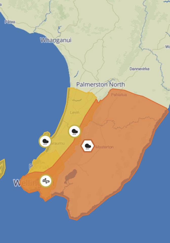
Heavy rain in South Wairarapa is expected to spread northwards this afternoon. Expect 80 to 120 mm to accumulate, but 150 to 250 mm about the ranges and coastal hills. Peak rates of 15 to 25 mm/h, but 25 to 40 mm/h possible in localised places, especially in thunderstorms.
Moderate chance of upgrading to a Red Warning.
Streams and rivers may rise rapidly. Surface flooding, slips, and difficult driving conditions are possible.
Clear your drains and gutters to prepare for heavy rain. Avoid low-lying areas and drive cautiously.
We are monitoring the situation and will put out any updates as needed.
The map below shows the affected areas.

-------
19 April 2026
MetService have issued a heavy rain warning for the Tararua District south of Woodville:
![]() 31 hours from 11:00am Mon 20 Apr to 6:00pm Tue 21 Apr
31 hours from 11:00am Mon 20 Apr to 6:00pm Tue 21 Apr![]()
A period of briefly heavy rain may affect the region this evening before more persistent rain with heavy falls sets in during Monday. Expect 80 to 120 mm of rain from Monday morning, but 150 to 250 mm about the ranges. Peak rates of 15 to 25 mm/h, but 25 to 40 mm/h possible in localised places from Monday afternoon.
Moderate chance of upgrading to a Red Warning.![]() Streams and rivers may rise rapidly. Surface flooding, slips, and difficult driving conditions are possible.
Streams and rivers may rise rapidly. Surface flooding, slips, and difficult driving conditions are possible.![]()
Clear your drains and gutters to prepare for heavy rain. Avoid low-lying areas and drive cautiously.![]()
The map below shows the affected area: